 Ancient watchtower on the cliffs at Cerro Gordo, overlooking La Herradura bay.
Other articles you may enjoy:
Photographs I love …. and why!
Ancient watchtower on the cliffs at Cerro Gordo, overlooking La Herradura bay.
Other articles you may enjoy:
Photographs I love …. and why!
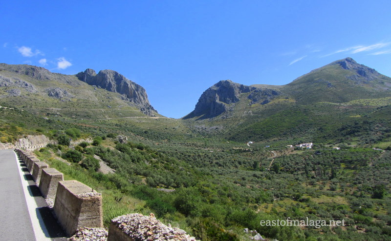
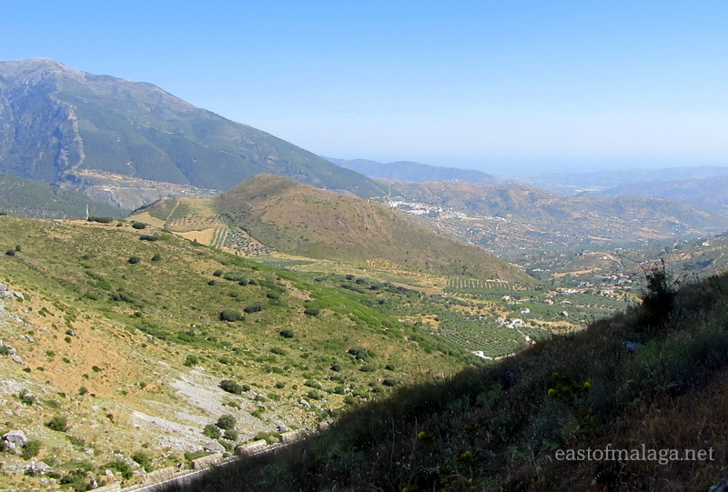
You might remember, I’ve told you before about the spectacular U-shaped Zafarraya Pass (El Boquete de Zafarraya) marking the boundary between the provinces of Málaga and Granada, and which can be seen for miles around.
Standing over 900 metres above sea level, the Pass has been used for centuries as a key route through the sierras, linking lands south-west of Granada, with the towns and villages along the coast, east of Málaga.
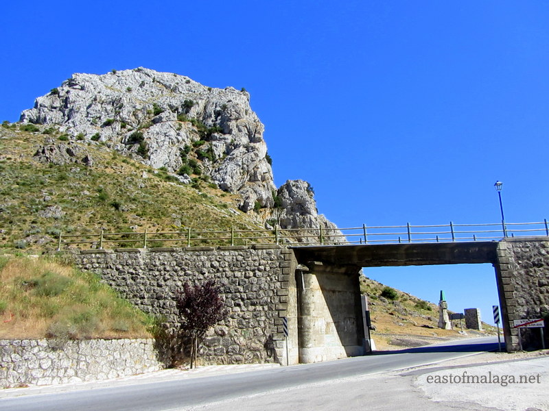
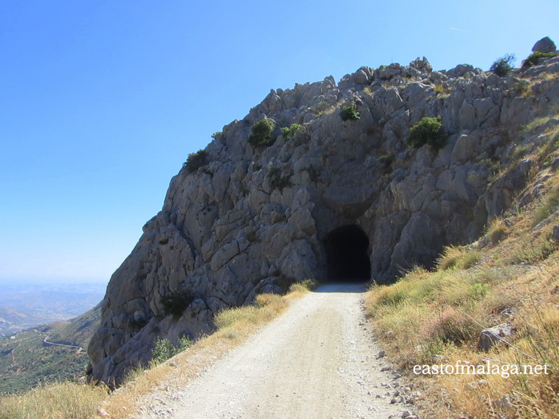
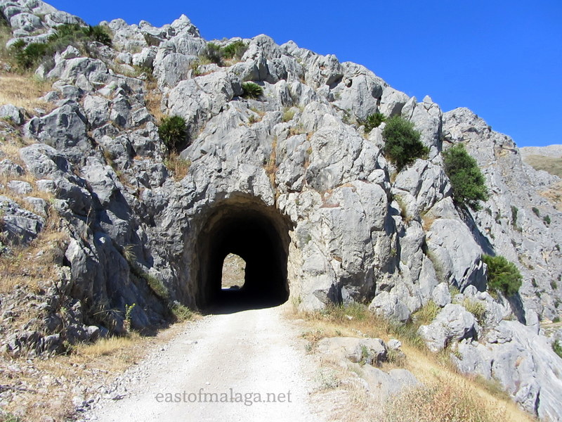
On the approach to the gap in the mountains, above the road on the left, a small tunnel through the rock can be seen. This once formed part of the Periana to Zafarraya railway line, abandoned fifty years ago. The tunnel is now used by horse-riders and walkers who enjoy strolling along the dirt road where the railway once ran.
Last time I went through the Zafarraya Pass, instead of whizzing by, I decided to stop and have a look. After driving under the the old iron railway bridge, I parked in the small car park on the left side of the road.
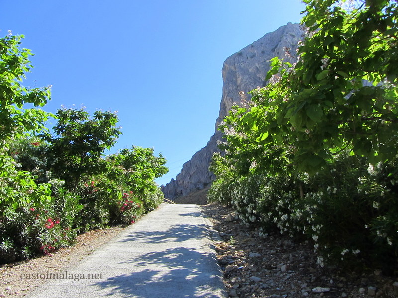
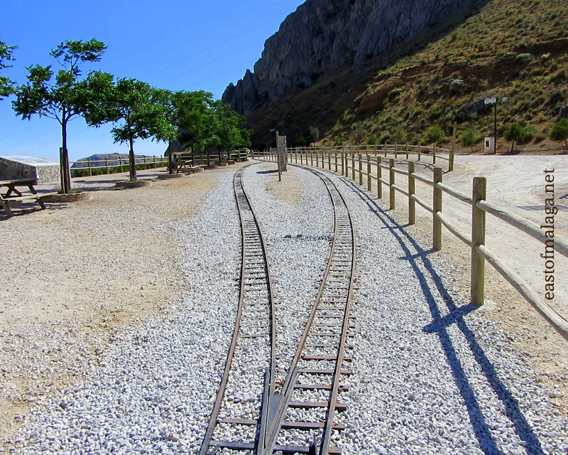
It’s only a few steps up the gentle slope to where the narrow gauge railway once ran. The main tracks were removed long ago, but there is still a short length remaining to illustrate what it must have looked like.

The views from the Mirador El Boquete (lookout point) both across the Pass and down towards the coast are stunning. This is a lovely peaceful place to stop for a picnic, and there are a couple of picnic tables for public use.
From here you can see the peaks of Tajo de la Cueva and El Morron de La Cuña, the hamlets of Espino, Los Cortijillos, Los Pavitos and Los Morales as well as numerous white houses, dotted like paint spots on a canvas, as far as the eye can see. The village of Alcaucín and the Parque Natural lie ahead, overseen by La Maroma, the highest mountain in the Axarquía region at 2066 metres.
If you cast your eyes further down the valley, La Viñuela reservoir and the Mediterranean Sea glimmer in the distance.


I wandered along the dirt track, and ahead of me I could see the old narrow railway tunnel.
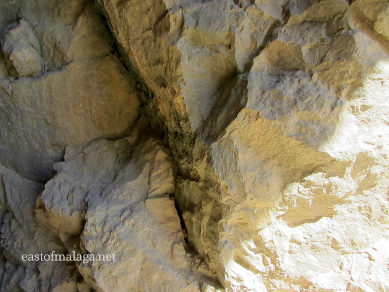
As I approached, the enormity of the task in building the tunnel was obvious. It had been hewn through the rock by hand. What a job!

Rather than just strolling as I did, and depending on how fit you are, you might enjoy an adventurous walk or a more gentle ramble from Periana, the source of the old railway line, back to the Boquete de Zafarraya.
Whatever you choose, be sure to watch out for the fabulous birds.

To get to the Zafarraya Pass, drive north from the A7/E15 Autovía del Mediterraneo, past the town of Vélez-Málaga and briefly alongside Lake Vinuela, before heading up the A402, a winding mountain road.
You will see the gap in the mountains ahead, getting closer and closer the higher you climb.
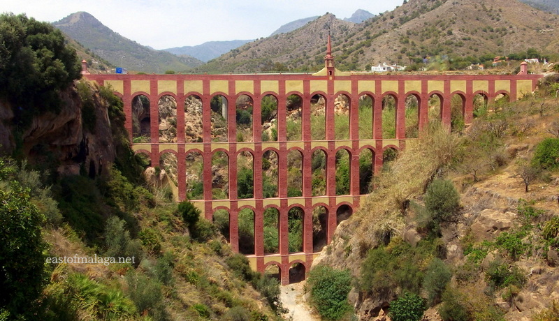
The Eagle Aqueduct (El Puente del Águila) was built in the 19th century as a means of supplying water to the San Joaquín sugar factory on the outskirts of the town of Nerja.
Damaged during the Spanish Civil War, but recently restored, the Eagle Aqueduct comprises four storeys of superimposed brick arcades with 37 arches. Soaring high above the spire at the central point of the structure is a weather vane in the shape of a double-headed eagle, from which the aqueduct takes its name. The structure is 40 metres tall and 90 metres wide, with it’s design being typical of the period of construction, when the Mudéjar-style was very popular.
Situated on the Barranco de la Coladilla and spanning a ravine close to the Nerja Caves and the village of Maro, the aqueduct is visible from the old N340 coast road linking Nerja with Maro. With a backdrop of the Sierra Almijara, it´s easy to see why this is one of the most photographed images of the local area. There is a lay-by at the side of the road where you can leave the car to get a good view or to take photographs of the monument. The area surrounding the aqueduct is public land and free to visit.
Strangely, the facade visible from the viewpoint is the rear of the construction, as the aqueduct faces north. The Eagle Aqueduct was NOT built by the Romans, as many believe, though the remains of a Roman bridge and the old Roman road to Malaca (Málaga), were unearthed nearby.
Despite the closure of the San Joaquín sugar mill many years ago, the aqueduct continues to be used for the irrigation of local farmland.
Related articles:
Sweet memories: San Joaquín sugar mill
La Viñuela reservoir: Water levels
The spectacular U-shaped Zafarraya Pass (El Boquete de Zafarraya) which marks the boundary between the provinces of Málaga and Granada can be seen for miles around. Standing impressively over 900 metres above sea level, the Pass has been used for centuries as a key route through the sierras, linking lands south-west of Granada, with the towns and villages along the coast, east of Málaga.
Although I have made the journey through the Pass many times, I never fail to be impressed by this ancient route through a huge cleft in the mountain spine of the Sierra de Alhama.
The name Zafarraya may have come from the Arab Fahs al-raiyya meaning “field of shepherds”, although there are people who think it derives from Saiarraya, meaning “territory limit”, referring to the fact that at one time Zafarraya belonged to the province of Málaga.
To get there, we drove north from the A7/E15 Autovía del Mediterraneo, past the town of Vélez-Málaga and briefly alongside Lake Vinuela, before heading up the A402, a winding mountain road towards the Pass.
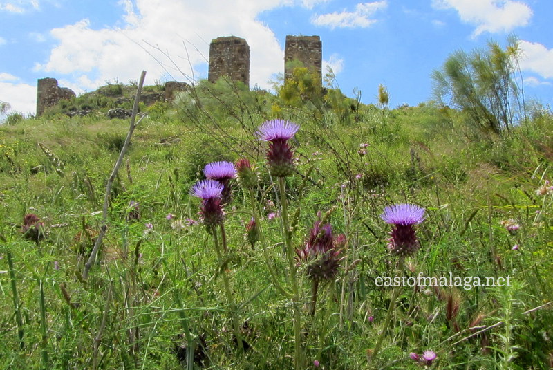
Along the way we stopped at the ruins of Zalía castle (castillo de Zalía) which sits on a hill opposite the white Andalucían village of Alcaucín. It is thought that the Phoenicians established the foundations of the fortress, but the castle was later built by the Moors around the 10th century to guard the ancient Nasrid Route through the Zafarraya Pass from Granada to Málaga.


Even though many of the wildflowers I have told you about over recent weeks have now started to die back near to where I live, they are still flourishing in abundance further inland, so we stopped many times to take in the natural beauty as well as many photographs.


In 1979, a cave was discovered near to the Zafarraya Pass (Cueva del Boquete de Zafarraya), with a subsequent archaeological dig unearthing the best preserved remains of Neanderthal man (radiometrically dating back 30000 years) ever found in Western Europe.
Importantly, the find was one of the first pieces of definite evidence showing that Neanderthals co-existed with modern humans for almost 10,000 years, disproving earlier theories that they had been quickly replaced by modern man.
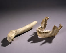 Image from: Museo de Málaga
As we approached the gap in the mountains, the entrance to a small tunnel through the rock can be seen, which was once part of the former Periana to Zafarraya railway line, abandoned fifty years ago. The tunnel is now used by walkers who enjoy strolling along the former railway line, which is now a dirt road.
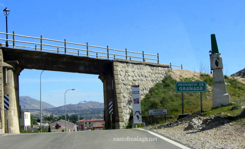
The old railway bridge across the road as you drive through the Zafarraya Pass is a more obvious relic of the old railway line.
It is here that you can find the village of Ventas de Zafarraya, so named because in times long past, travellers would stop for food and shelter at one of the local inns (ventas), where they could also exchange and refresh their weary horses and oxen, before continuing on their long journeys.
These days, Ventas de Zafarraya is almost entirely dedicated to vegetable growing on the fertile, flat land just beyond the village, where many different vegetables including lettuces, artichokes and beans are grown up rustic canes cut from nearby river banks.


Many of them are not much bigger than my little veggie plot at home!
Related articles:
Classic Andalucía: La Alhambra, Granada
Wildflowers of Andalucía: Dutchman’s Pipe
The Green, Green Vegetables of Home
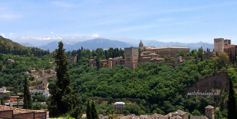 View of the Alhambra from the Mirador de San Nicolás in the Albayzin of Granada.
The Alhambra, a UNESCO World Heritage site is a palace and fortress complex located in the classical Andalucían city of Granada, Spain. It was originally constructed as a fortress in the year 889 and later converted into a royal palace in 1333 by Yusuf I, Sultan of Granada.
La Alhambra’s Islamic palaces were built for the last Muslim emirs in Spain and its court of the Nasrid dynasty. After the Reconquest by the Catholic Monarchs in 1492, some portions were used by Christian rulers. The Palace of Charles V, built by Charles V, Holy Roman Emperor in 1527, was inserted in the Alhambra within the Nasrid fortifications.
After being allowed to fall into disrepair for centuries, the Alhambra* was rediscovered in the 19th century by European scholars and travellers, when restorations commenced.
It is now one of Spain’s major tourist attractions, exhibiting the country’s most significant and well known Arab-Islamic architecture.
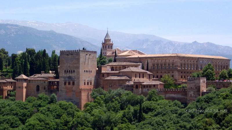 The Palace of Charles V – within the Alhambra, as viewed from the Mirador de San Nicolás in the Albayzin of Granada.
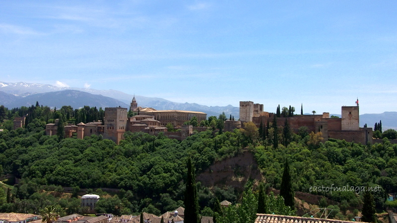 View of the Alhambra from the Mirador de San Nicolás in the Albayzin of Granada.
My final three shots were taken on Monday afternoon as we were having lunch in one of the wisteria-covered restaurants in Paseo de los Tristes. Perched above the Rio Darro at the end of Carrera del Darro, this plaza was once one of the busiest gathering spots in Granada, positioned along a curve of the river between the Alhambra and the Albayzin. These days, Paseo de los Tristes is a popular place to eat, with restaurants lining the north side of the square and magnificent views of the Alhambra soaring above.
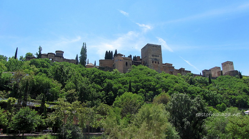 View of the Alhambra from the Paseo de Los Tristes, Granada.
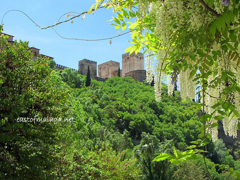 View of the Alhambra through the Wisteria, from the Paseo de Los Tristes, Granada.
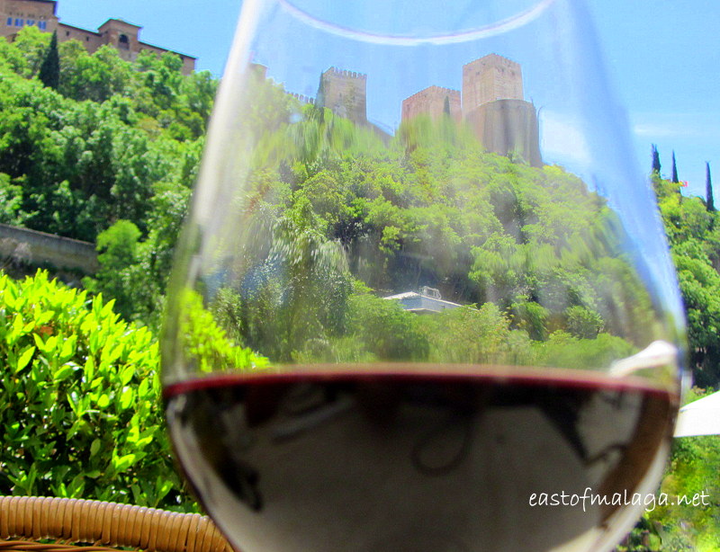 View of La Alhambra viewed through my particularly delicious glass of Rioja, as I was having lunch – CHEERS!
* Information about the Alhambra retrieved from Wikipedia
Related posts:
Ubirr Rock, Northern Territory


